After Cyclone Mandous, Another Low-Pressure Forms Over Bay of Bengal

A Low Pressure Area formed over the Southeast Bay of Bengal adjacent to the South Andaman Sea on Wednesday afternoon. It will move westward and is likely to become a depression by Thursday. The Indian Meteorological Department (IMD) said in a report on Wednesday night that it will continue with the same intensity and direction till the 17 of this month.
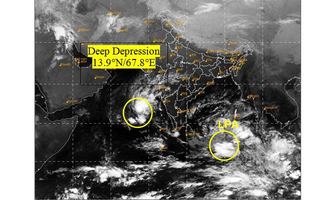
Depression over East-central Arabian Sea intensified into a Deep Depression and lay centered at 0530hrs IST on 15th Dec 2022 about 580km west-northwest of Aminidivi (Lakshadweep), about 630km west-southwest of Panjim(Goa) To move W-NWwards away from Indian coast and weaken gradually.
The Low Pressure Area now lies over Southeast Bay of Bengal & adjoining the East Equatorial Indian Ocean. It is likely to move gradually westwards and become Well Marked Low Pressure Area over the same region during the next 12 hours.
Deep Depression over Eastcentral Arabian Sea about 620 km west-northwest of Aminidivi (Lakshadweep).To move westwards away from Indian coast, maintain intensity of DD till early hours of tomorrow and weaken gradually thereafter. pic.twitter.com/ByAhWgXq3u
— India Meteorological Department (@Indiametdept) December 15, 2022
But if it does strengthen into a cyclone it could well become the third cyclone over the Bay of Bengal this year. The first was Cyclone Sitrang which hit during the Diwali week in October, and the second was Cyclone Mandous which formed just a week ago affecting several parts of Andhra Pradesh and Tamil Nadu. As per the weather cycle, December marks the end of the cyclone season in the North Indian Ocean.
The IMD has already forecast heavy rainfall across Tamil Nadu, Puducherry, and Karaikal for next Monday (December 19) and Andhra Pradesh is not on the list as yet.
Click below for the latest update as on 15-12-2022


